Friday, September 12. 2008
Finding dark places in Austria

Recently I took my first star trail images with my DSLR. There finally was no moon and clear sky, so I took my photo backpack and my tripod with me and drove at 2.00am a few kilometers outside the small town where we were staying that weekend. It was located in the Waldviertel (“Woodquarter”), a rather sparsely populated region at the north of Austria, and so I expected best conditions for taking pictures of a starry night. Indeed, the Milky Way was clearly visible. I pointed my camera northwards to capture the sky rotation, and although it was really dark, I was a little surprised that the trees silhouetted against the sky. And a long time exposure unveiled a faint orange glow at the horizon, although the next populated spot in that direction was a small village a few kilometers away.
This finally raised the question to me: How should I find the sparsest populated place within a certain radius? What data would I need to find that out? A set of coordinates of towns plus their number of inhabitants? Use that to compute an image and blur it? Or rather, is it possible to use data collected in the course of the light pollution issue?
By some research I was finally able to find
- the darkest place near the Waldviertel and
- the darkest place in Austria.
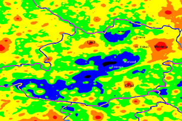
I started with a map by LightPollution.it, tried to identify urbanized areas by the help of Google Earth and added some town names:
The spots that interested me were the blue area at the north of Austria and the black one in its center. The former covers parts of the southern Waldviertel (in the east) and of Upper Austria (in the west). The latter is already located near the Austrian Alps, but surprisingly not in their center.
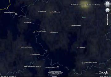
Let’s look at the dark Waldviertel spot first: No surprise as well that its eastern tail covers parts of the Austrian Armed Forces’ proving ground Allentsteig. Although that area isn’t sealed off and regular roads lead through it, photography is forbidden there, possibly although it might be pitch-dark and you just point your camera at the sky. So I focused on the western part of that area in Google Earth. I switched on the NASA layer, which is categorized under Gallery, showing earth’s city lights at night. Even small villages become faintly visible. I noticed that the darkest area is located along the border between Lower and Upper Austria. I spotted some potential places near the small roads. (Note that the lines in the screenshot below indicate borders, not roads.)
The next night sky images will probably be shot at one of those places. Btw, the Martinsberg observatory is near that area, too.
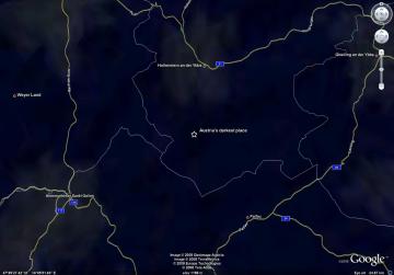
Let’s look at Austria’s darkest place now. It’s located somewhere at the south of Upper Austria, around 47°45’ North and 14°45’ East.
I don’t know whether I’ll ever go there for watching the stars. And I also don’t know yet whether I’ll ever switch over to real astronomy. Astro equipment is expensive and hardly mobile. The light pollution in the area I’ll soon live in is not that bad at least.
And I don’t really understand why there are many observatories located in urbanized areas. I can’t imagine that they’re able to watch deep sky objects reasonably well. I’m looking forward to our holidays on the Canary Islands, where the sky is probably quite dark. I’m not sure whether I’ll ever be to really abandoned places like deserts, although they’re the best places for earth-based astronomy.
About
Calendar
| Mon | Tue | Wed | Thu | Fri | Sat | Sun |
|---|---|---|---|---|---|---|
| ← Back | February '26 | |||||
| 1 | ||||||
| 2 | 3 | 4 | 5 | 6 | 7 | 8 |
| 9 | 10 | 11 | 12 | 13 | 14 | 15 |
| 16 | 17 | 18 | 19 | 20 | 21 | 22 |
| 23 | 24 | 25 | 26 | 27 | 28 | |


www.tl-photography.at on : PingBack
tl-photography on : Light Pollution